


+70
°
F
+74°
+58°
Niagara Falls
Thursday, 16
See 7-Day Forecast
Featured News - Current News - Archived News - News Categories

By Michael J. Billoni
Recently, officials from the Niagara River Greenway Commission met with Town of Grand Island committee members who are working on its trails and bike routes. They took a bicycle ride down Grand Island Boulevard to finalize a direct route through town to officially connect the extensive Niagara River Shoreline Trail from Buffalo’s Outer Harbor north to Youngstown.
Leading the ride were Executive Director Greg Stevens; Michelle Lockett, the community engagement manager; Councilman Pete Marston; Jim Sharpe, the town’s Long Range Planning Committee chairman; Paul Leuchner, a Long Range Planning Committee member; Paul Yaeger, Conservation Advisory Board member; and Roger Cook, Economic Advisory Board member.
“We have had many meetings with Town Supervisor (John) Whitney, members of the Town Board, Jim Sharpe and the Long Range Planning Committee, members of the Parks and Recreation Department and other committees to discuss the many opportunities Grand Island has with its many trails and paths,” Stevens said. “The West River Shoreline Trail is absolutely fantastic and is clearly the jewel of the entire Niagara Region, drawing many visitors to Grand Island.”
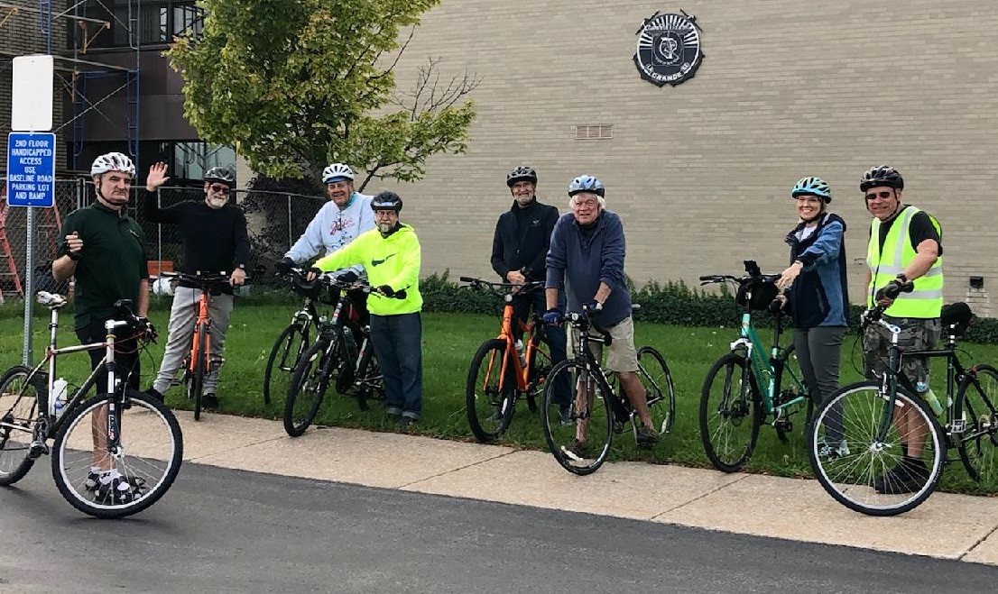
From left: Greg Stevens, Pete Marston, Mike Billoni, Paul Yaeger, Jim Sharpe, Roger Cook, Michelle Lockett and Paul Leuchner.
••••••••
Sharpe, a strong advocate of Grand Island promoting its many outdoor activities and trails, said, “It’s absolutely fantastic to have such an engagement by the Niagara River Greenway Commission in this project on Grand Island by having them actually take bike rides with us. They are truly taking the time to look closely at Grand Island, feel its environment and see firsthand what the paths on the Island are doing to improve the environment and clearly make this a true Greenway project.”
Greenway needs to finalize a direct route from bridge to bridge for cyclists riding the Shoreline Trail. It will add directional signs to the West River Shoreline trail as an option and, hopefully in the future, add a completed East River Road bicycle trail to the map. For this ride, their attention was on Grand Island Boulevard, from the South Bridge north to the North Bridge.
Stevens and Lockett’s third bicycle ride with town officials over the past two years began at the one obstacle on Grand Island Boulevard, from Whitehaven Road to Baseline Road.
“That block is viewed as the most dangerous single street block in the entire Greenway Trail,” Stevens said bluntly before leading them through the Rite Aid parking lot; north on Baseline Road; west on Bedell Road; north on the Linear Trail; west on East West Park Road; across the bridge over the 190; south on the small trail connecting to West River Shoreline Trail; West River Shoreline Trail; to Bedell Road; and south on Grand Island Boulevard to Town Hall.
Here are the observations of Stevens, a long-time cyclist in the U.S. and abroad:
•The Whitehaven to Baseline roadblock is very dangerous and needs to be fixed ASAP by creating a temporary bike lane or moving cyclists onto the sidewalk.
•It is critical the road is redesigned here to truly create a town center.
•There is a vast amount of space on this road, which is poorly used and only encourages high-speed auto traffic.
•Town centers are safe for pedestrians and bicyclists, and they have lots of greenspace, slow traffic, traffic circles, accessibility to shops, recreation, etc.
•Rite Aid should be approached to consider putting a bike path through its parking lot to make the turn onto Baseline Road shoulder safer and easier.
•Baseline and Bedell roads will have New York State Shoreline Trail directional signs installed.
•This group agreed a trail through the National Grid easement from Baseline to Bedell is a good idea.
•Everyone also agreed the linear trail is a treasure. It provides a heavenly bit of riding, and it always seems busy with walkers and riders. It needs more parking, access, and extension on both ends.
•East West Park Road – Great to see new paving and shoulder markings. This was designated as a high-priority bike route back in 1968. Wondering why there no bike logos in the shoulder?
•Crossing the 190 – this is a very dangerous path from the south with signage that deludes riders to think they should get on the 190 access road. Need to improve marking striping and signage.
•Path from 190 to West River Shoreline Trail – it is extremely valuable this is here and off road. It just needs paving and widening.
•The West River Shoreline Trail needs more connections to the town and signage of such.
•Street stubs entering the median should be converted to parking by just moving bollards west to the trail’s edge.
After the ride, the group held an informal poll during discussions in the Town Hall parking lot and came up with these conclusions, which it hopes town officials and the various committees will consider this winter in preparation for the 2022 bicycle season:
•Make continuous trails all around Grand Island and publicize them.
•Connect gaps in the current trail network.
•Make big connections like Grand Island Boulevard to Baseline Road to Bedell Road to the linear trail to the West River Shoreline Trail.
•Over the long-term, develop long trails on easement corridors.
•Take small steps toward this as pilot projects like Bedell Road to Baseline Road on the National Grid corridor.
•There is not enough town land to build trial systems, so look for corridor opportunities.
•Create a new walking/mountain bike trail 2-3 – 5 miles at South Point and Baseline Road to Staley Road and Glen Avon. How would you tie that into the trail network?
•Current Nike Base trails need to be better connected to West River Shoreline Trail to provide rest rooms and integrate the recreational options.
•Make a connection from Six Mile Creek Marina to West River Shoreline Trail.
•Ultimately, they would like to see a safe ride all around Grand Island, including East River Road for a 26-mile loop, which would promote events as running and cycling marathon and races, such as Triathlons.
•East River Road needs a long-term solution to be safer, but the solution is not obvious, so we need to move forward with other safer riding options in the meantime.
The group agreed the best immediate option is to connect a shoreline trail loop from bridge to bridge including a town center loop, West River Parkway, the South Parkway and the Baseline/Bedell/linear trail connection via Buckhorn State Park.
Marston, a strong advocate of the trail system throughout the Island – who held a tour of the trail at the Nike Base last week for a similar group – said, “So often we sit at a table and discuss projects at length. This was healthy to ‘put the rubber to the road’ and see opportunities for our town in person. There are some exciting opportunities here for our residents and visitors to our Island.”
Lockett, a long-time Island resident who resides here with her husband and two children, added, “I am thrilled to see all the recent trail developments on Grand Island and excited to see the finished product. Niagara River Greenway is all about creating world-class trails and green spaces along the Niagara River, and Grand Island has the potential to be a fantastic ecotourist destination!”
Sharpe, charged with leading a volunteer committee in developing a long-term strategy for growth and development of Grand Island, was excited to be part of the ride with Stevens and Lockett.
“The Greenway Commission is not taking this lightly and we are demonstrating to them that we have already created a good trails system on Grand Island. Their expertise can only help,” Sharpe said.
For information about the Niagara River Greenway, visit www.niagararivergreenway.com.
Supervisor Whitney said the town website now has maps for its trail. Visit http://www.grand-island.ny.us/maps/engineering/index.php, click on Island Trails on the left side bar, from the drop-down list and choose from the Bikeways, Hiking Trails and Blueway Trails.
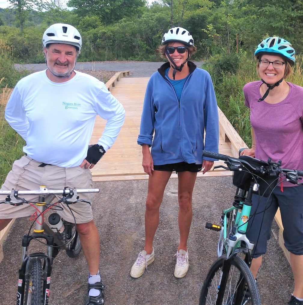
Michelle Lockett, right, Greg Stevens and Deborah Billoni, a member of the Town Long Range Planning Committee, during a recent ride through island trails.
••••••••
HOW TO MAKE BIKING SAFER
Michelle Lockett, the community engagement manager of Niagara River Greenway Commission, has resided on Grand Island since she was a young girl. She recalls growing up playing in the fields and bring home pollywogs every spring. She is happiest when partaking in an outdoor activity such as camping, hiking, biking, skiing, ice skating, yoga or kayaking.
Married and a mother of two, she passionately believes everyone should be outside as much as possible, enjoying their favorite activity. She works closely with Greg Stevens, executive director of the commission. One of their many tasks is completing the Niagara River Shoreline Trail, which stretches from the Buffalo Outer Harbor north to Youngstown. A key task has been ensuring a safe route for riders to cross the island. When New York State Parks places the directional signs for bikers at the base of each bridge, there will be two routes they can consider: a direct one through town or a longer distance along the west river on the new bike and walking path.
“It is very exciting for me as an Island resident and a member of the Rotary Club of Grand Island, to be working closely with Town Board member Pete Marston, Highway Superintendent Dick Crawford, Town Supervisor (John) Whitney, the Greenway Commission, and New York State Parks to build up our Island as the ecotourist hot spot for the Niagara Region,” she said. “Every stakeholder in meetings we have held knows the value of Grand Island’s natural resources, and we are determined to utilize them in the most economical and safe way. Identifying safe bicycle routes, connecting our bridges, is an important first step in bringing out-of-town ecotourists onto our Island.”
Stevens and Lockett have been a part of three bicycle rides on Grand Island to determine the best route for cyclists passing through along with exploring the many trails the town offers. The most direct route from the north Grand Island bridge to the South bridge takes riders around the edge of the traffic circle and onto Grand Island Boulevard to Baseline to Bedell where they turn right onto the linear trail, which they follow to East West Park Road, where they turn left onto a paved path in Buckhorn State Park that leads to the entrance of the bridge.
Lockett put together this information about that route and the group’s concern about a dangerous stretch on Grand Island Boulevard, from Whitehaven to Rite Aid:
√ Did you know the sidewalks on the Grand Island bridges are a safe off-road bike path that connects bike riders to Grand Island Boulevard?
√ Did you know New York state recently completed a bike path that travels across the entire state, passes right by the south bridge, is part of the Shoreline Trail and expects 8 million cyclists a year? Information can be found at https://empiretrail.ny.gov/.
√ Did you know the entire length of Grand Island Boulevard is designated as a bike route by New York state and the Greater Buffalo Niagara Regional Transportation Council, and it is listed in the Regional Bicycle Master Plan?
√ Did you know that many cyclists are indeed riding over the bridge and onto the Grand Island Boulevard bike route?
√ Do you know what happens after the off-road path ends right after the traffic circle and the Tim Hortons parking lot entrance? Cyclists then ride on the shoulder of Grand Island Boulevard, which is OK until you reach Whitehaven Road. The stretch to Baseline Road is OK for the career cyclist, but not ideal for the casual cyclist, who should ride off the road at that stretch.
√ We are currently working with the State Parks on signage to direct riders down Grand Island Boulevard to Baseline to the linear path to the East West Park Road. We hope to have them installed in the spring.
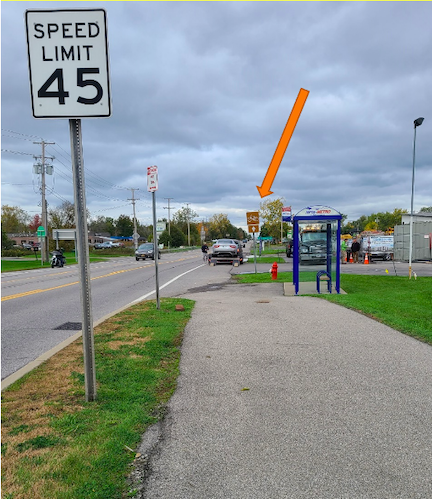
PHOTO 1: There’s a safe off-road path from the Grand Island south bridge to Tim Hortons parking lot, but then cyclists are forced to ride on the shoulder of Grand Island Boulevard.
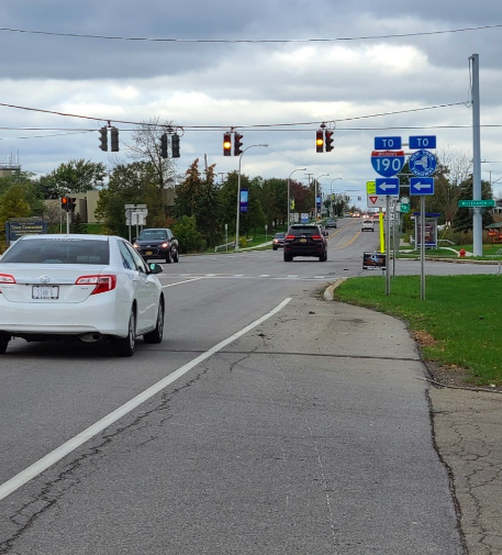
PHOTO 2: The shoulder works well until you come up to Whitehaven where it gets very dangerous because the shoulder completely disappears.
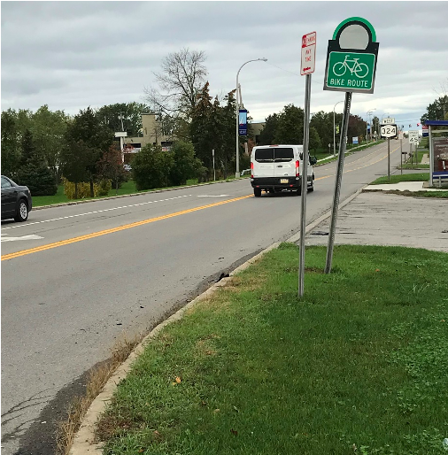
PHOTO 3: Yet, the bike sign just past the intersection of Grand Island Boulevard and Whitehaven Road is prompting riders to bike through traffic, which travels at 45 or 50 mph.
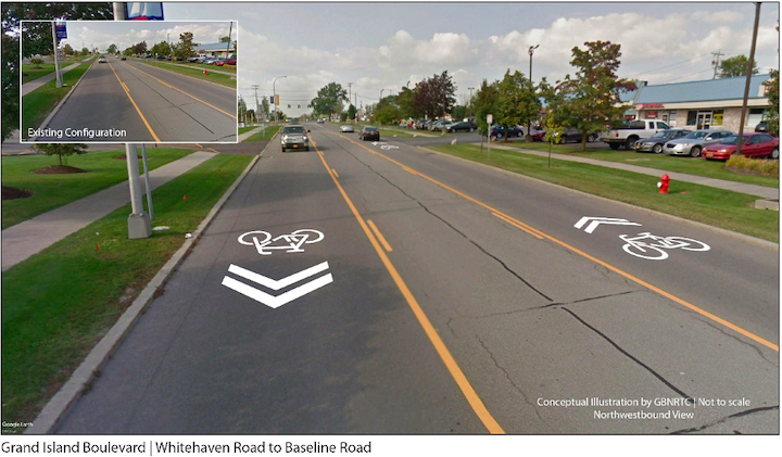
PHOTO 4: So, what does Grand Island do about this before someone gets hurts? One option is to keep in road cycling and lower the speed limit and paint on road bike stencils, like this:
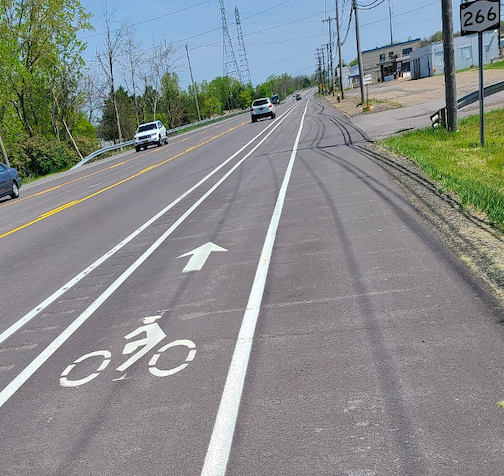
PHOTO 5: Or we could give the road a road diet and try to do something like what was just done on River Road in Tonawanda that has a separate cycle lane like this:
If you are interested in contributing your ideas or comments on how to make cycling safer on Grand Island, especially on this tract of Grand Island Boulevard, please send them to [email protected].


1859 Whitehaven Road, Grand Island, NY 14072
Phone: 716-773-7676
Fax: 716-773-7190
