


+70
°
F
+74°
+58°
Niagara Falls
Thursday, 16
See 7-Day Forecast
Featured News - Current News - Archived News - News Categories
By Karen Carr Keefe
Senior Contributing Writer
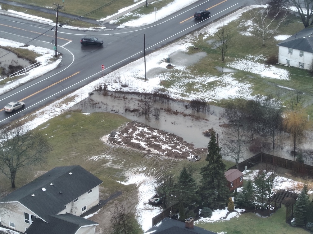
April showers bring May flowers, but on Grand Island, more rain has the potential to bring more drainage problems.
Recent drone mapping documents the issue the town is facing.
The images could help as Supervisor Peter Marston and fellow Town Board members are continuing to work on a solution to the town’s persistent flooding.
On Feb. 5, the Town Board passed a resolution seeking support from government and agency officials to allow the municipality to fix the problem of poor drainage. The vote was spurred by damaging flooding on Jan. 26.
Marston said the town monitored that flooding via drone mapping, then redid the drone investigation when the ground was dry for comparison.
Now there is video evidence to support the town’s request for government aid in easing rules and providing funding to prevent flooding, Marston said. One of the agencies contacted for support is the state Department of Environmental Conservation.
“We talked about doing this initially, and I’ve seen the product, and it’s pretty amazing. It’s very, very telling,” Marston said recently in a conversation with the Island Dispatch. “We’ve already shared some of them (the drone images) with the DEC. We’ve shared them with some of our hierarchy of elected officials.”
Marston said Assemblyman Angelo Morinello “seems to be a champion on this. He’s seen this throughout his whole district – beyond us. Niagara County has got some pretty glaring issues.
“It was one of those issues everybody had, but nobody really could talk about. Now we’re all going to talk about it together. And now they’re starting to understand that we’ve got a problem.”
Marston said town officials had some meetings with DEC representatives. “They’re like, ‘Well, you could pull some local permits.’ ” He sent DEC some of the drone mapping videos, and their reply, Marston said, was “ ‘OK, I think we need to talk a little bit more.’
“They realized that getting a permit to go remove a tree isn’t going to do, because there’s hundreds of them. The water is actually not following its intended paths in a serious flooding event. We’ve also reached out to State Parks, because the one major watershed, Woods Creek, goes through Buckhorn (State Park.)
Back in February, Marston said, “The emerald ash borer effect on Island trees has been devastating. Downed trees and silt are plugging the waterways, and regulations discourage the extent of the cleanup that is needed.
“There are so many rural, wooded areas where these things just aren’t being cleaned out. There’s fallen trees packed in with mud and debris,” keeping the creeks from flowing as they used to.
Marston said getting the DEC to acknowledge the problem is a significant step forward, and cooperation between the interested parties is essential.
He said the DEC, working jointly with the Army Corps of Engineers, could establish a maintenance plan to alleviate the flooding.
“That’s the only way we’re really going to get there is to get everybody on the same page,” Marston said. “It seems like it’s an awful lot of work, but I think it’s worth it.”
He said the problem isn’t going to fix itself – and without intervention, the flooding will only get worse over time.


1859 Whitehaven Road, Grand Island, NY 14072
Phone: 716-773-7676
Fax: 716-773-7190
