


+70
°
F
+74°
+58°
Niagara Falls
Thursday, 16
See 7-Day Forecast
Featured News - Current News - Archived News - News Categories
Phase III scoping opens for Niagara Scenic Parkway
√ State officials discuss parkway design options with public
√ Construction on parkway improvements could start in 2028
By Terry Duffy
Editor-in-Chief
Consultant teams representing the New York State Office of Parks, Recreation and Historic Preservation; the New York Power Authority; New York State Department of Transportation; and various local stakeholder groups provided insight Tuesday on the future of the Niagara Scenic Parkway in a well-attended public information session at DeVeaux Woods State Park.
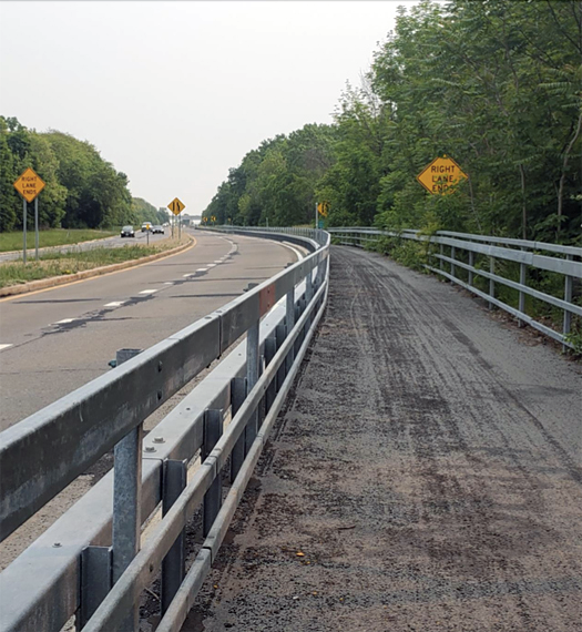
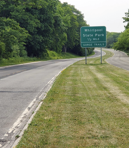
Mark Mistretta, State Parks regional director, opened the phase III scoping discussions on the parkway by recalling the successes of its phase I and II improvements. Known earlier as the Robert Moses State Parkway, significant work was done on the roadway in 2006 from the north Grand Island bridges to Niagara Falls State Park. Phase II work began in 2013 and transformed the parkway from its expressway-type vehicular traffic setup to parkland and trails along Whirlpool Street to Findley Drive.
“This next phase – it’s a little bit more involved; there’s more roadway networks. A lot of people have been asking (about it). We don’t know yet,” Mistretta said as to the future parkway designs. “We have some concepts we developed, but we’re really here to listen.”
Tuesday’s session was presented as “the first outreach” to gauge community interests, and Mistretta said state officials would hold future sessions over next 15-18 months as planning continues. “We’ll see how that goes.”
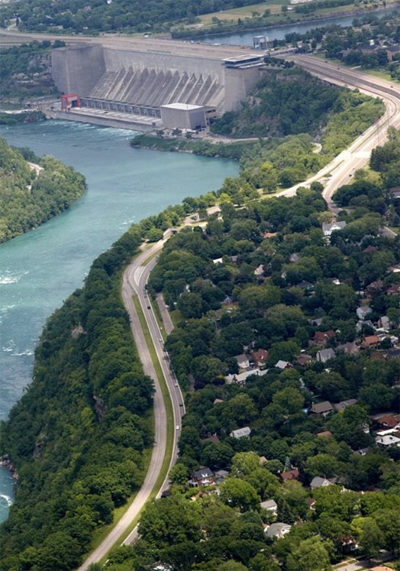
He said the scoping process coincides with a decking improvement process of three riverside traffic lanes over the NYPA power generating plant in Lewiston.
“The New York Power Authority is investing $1 billon in their three bridges over the dam,” he said. “The two projects are so intertwined, it’s incumbent upon us come up with the best solutions, the best designs … so it all works well together.”
Mistretta said State Parks is operating under a continuing agreement with its stakeholders developed under phase II of this project. These include Empire State Development, USA Niagara, the DOT and NYPA. “That is how a lot of this work is being done, and Parks is in the lead.”
Paul Tronolone, vice president of planning and policy for Empire State Development, served as the technical leader during phases I and II. He told attendees Tuesday that ESD, together with USA Niagara and NYPA, continue their work toward redefining the recreational elements of this ongoing project.
“The New York Power Authority actually owns a lot of the land upon which the parkway sits. It’s a combination ownership between State Parks and the Power Authority,” he explained
Tronolone said the original parkway construction was part of the NYPA Lewiston project back in 1962 and its continuing upgrades includes input from the federal government plus state and local interests.
“The parkway itself is part of the state parkway system and was created in the 1950s and ’60s,” he said. “The (original) Robert Moses Parkway was a four-lane expressway that ran from the Grand Island Bridge all the way up to Youngstown-Porter. And the calls for its removal started within a decade of it being completed.”
Tronolone explained the state’s corrective actions on the parkway began in the early 1980s with work on the southern segment (phase I) from the Grand Island bridges to Niagara Falls State Park. He said state officials have pursued multiple projects and plans toward a desired removal and reconfiguration of the parkway from 1990 to current day.
A 2000 pilot project completed by DOT reduced the original four lanes of parkway to two lanes, with two-way vehicle access along the southern segment, augmented by a trails system where the original traffic lanes were situated. The second phase in the northern zone removed all parkway lanes from Main Street to Findlay Drive at DeVeaux Woods State Park and was completed in 2020.
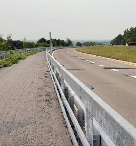
From Findlay Drive toward Center Street in Lewiston, the parkway features the one road, two-way vehicle configuration, with a river trail, before switching back to four lanes past the NYPA operations above the hill. It continues in this current arrangement toward Center Street.
Tronolone said DOT has continually studied traffic impacts from earlier parkway design changes and found the traffic impact to be minimal.
“We really didn’t have a big traffic movement along this four-lane expressway,” he said.
Total daily traffic impact is under 5,000 cars per day. “That’s a tenth of what runs of the 190. There are sections of the 190 that get north of 50,000 cars per day.”
Tronolone said traffic studies found that adjoining roads – Route 104 and others – “operate at an acceptable level of service right now. And even if you added all the trips on the parkway (in this study), you really wouldn’t have an impact from a daily commuting (scenario).”
“From a mere traffic standpoint there was never really a need for a four-lane expressway (in the first place)” he said.
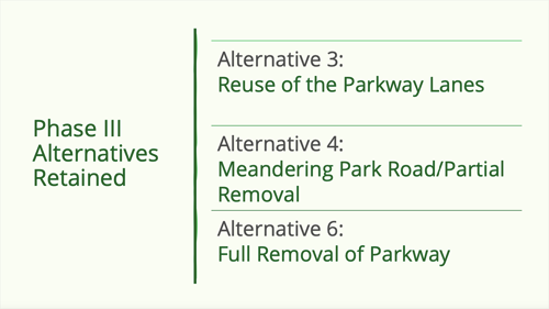
As far as phase III, from Findlay Drive from Center Street, consultant John Hubert, project manager of Colliers Engineering and Design, and staffer Kim Baptiste, discussed what’s ahead for this section, as three design alternatives from the original six plans were presented.
“Things are all open here,” Hubert said. “We’re not starting from ground zero; we’re trying to build on from (our initial planning). There’s a lot or reevaluation that we’ll need to do – the traffic, the environmental, the connectivity to neighborhoods, other points of interest. But we’re trying to carry forward the original ideas that were generated 10 years ago (from phase II).”
Hubert said phase III does not include any changes on the Niagara Scenic Parkway from Center Street north, telling visitors that section remains in the state’s long-range planning.
“I just wanted to reinforce it does not include the portion of the parkway north that goes to Youngstown,” he emphasized. “That’s not included in this present project.”
Hubert said a main difference in the phase III design versus phase II is there are no plans for work on the adjoining streets as was done previously with Whirlpool Street in phase II.
He noted the Greenway Commission is funding elements of the phase III design study and told attendees, “There’s no monies identified yet for final design or for construction at this point.”
Of phase III, he added, “We’re going to be looking at connectivity (with NYPA, Niagara University, plus the four state parks along the route); with the neighborhoods; traffic, points of interest, aesthetics, environmental. We’ll be starting with these three base alternatives and building from that and there could be modifications.”
Hubert said the NYPA corridor is being advanced as “a separate project. It’s been determined (the three traffic lanes over the NYPA dam) are at the end of (their) useful life. NYPA is working on plans to replace the decks on those bridges.”
He said NYPA’s traffic studies would assist state planners as phase III designs move ahead.
Hubert said the three alternative designs under consideration from six initially presented would involve some use of the existing northbound lanes in a two-way arrangement.
•Alternative 3 – Continuing reuse of the existing parkway lane setup from Findley Drive through Devil’s Hole State Park to the NYPA area, then reverting to two traffic lanes to Center Street.
“It’s basically extending the pilot project (of phase II) and continuing the full length of the (phase III) project corridor as a two-lane road,” he said.
•Alternative 4 – A meandering park road with a partial removal and a continuing trail to Center Street.
“It’s a smaller-scale park road that would not be continuous,” Hubert said. “It would run from Findlay up to Devil’s Hole State Park, and then pick up again from Upper Mountain Road up to Center Street. It would skip over the middle section (at NYPA) where the traffic would go over to 104.”
•Alternative 6 – A full removal of the parkway from Findlay Drive to Center Street, with no improvements to the exiting neighboring roadway as was done with Whirlpool Street.
“It would totally remove vehicular traffic from the edge of the gorge,” Hubert said.
Discussing the potential parkway alignments to neighboring streets under alternatives 3 and 4, Hubert said one scenario “would be a two-lane road; the waterside would be a continuous pathway network. It could include connections (vehicular, bike or both) to the neighborhoods.
“(That’s) to be determined; don’t take any of that as gospel right now.”
Hubert said modifications to Devil’s Hole, as well as changes to the parkway from NYPA to Center Street, are under consideration.
“It (would be) a continuous two-lane road,” he said. “It would use the middle section of the power plant as a three-level bridge (with) the middle section for vehicular traffic with interchange improvements to Upper Mountain Road.”
Hubert said a new overlook constructed in the Fort Grey Drive neighborhood and one being built into Artpark State Park will allow for greater access to the river areas, as well as to the concert venues at latter. “It’s something that Parks already has in the works now.”
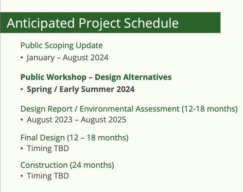
As far as an anticipated project schedule, Colliers representative Kimberly Baptiste said the public workshops and discussions on the design alternatives now underway would continue to August. Design reports and environmental assessments would follow, and be finalized by August 2025, followed by final design work on actual construction. She said this would take 12-18 months, and an actual timeframe still to be determined.
The project’s construction would take up to 24 months, with a startup envisioned in 2028.
“No decisions have been made,” she said. “We are building upon the alternatives started as part of the 2013 process (phase II). But those are open for refinement, for tweaking, based largely on the feedback and technical analysis.”
Baptiste said the parkway project has yet to receive any state funding beyond the initial Greenway money for design work, and that the related NYPA improvements are being managed by the Power Authority. In the meantime, the public scoping process continues, with future information sessions to be scheduled.
For more information on the Niagara Scenic Parkway project, visit https://www.niagaraparkwayremoval.com/.
Images courtesy of the New York State Office of Parks, Recreation and Historic Preservation.
Agencies involved with the parkway concepts


1859 Whitehaven Road, Grand Island, NY 14072
Phone: 716-773-7676
Fax: 716-773-7190
