


+70
°
F
+74°
+58°
Niagara Falls
Thursday, 16
See 7-Day Forecast
Featured News - Current News - Archived News - News Categories
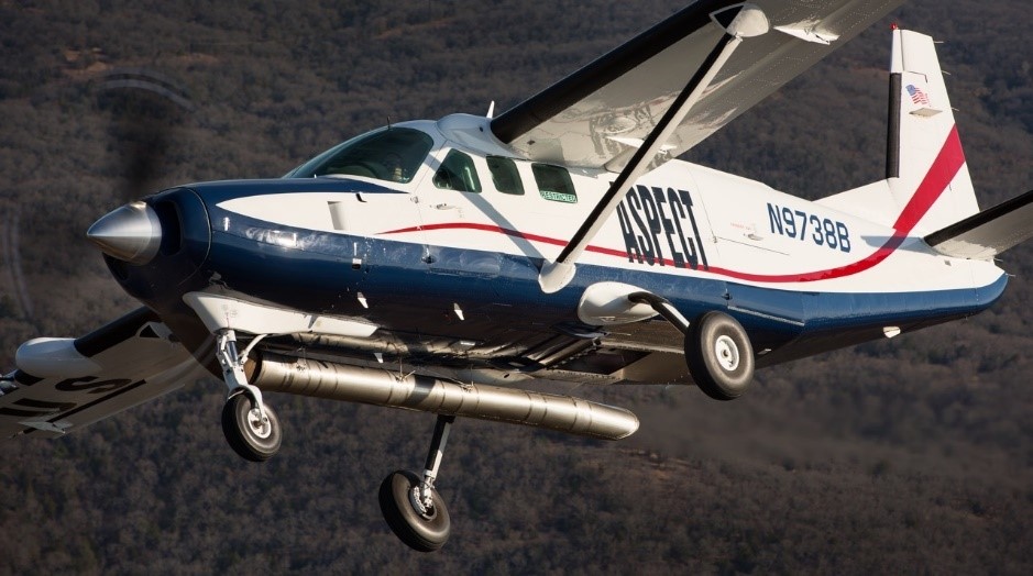
Low-flying plane equipped with latest radiological sensor equipment will collect data to update prior federal survey
Text and Photo Provided by the New York State Department of Environmental Conservation
The New York State Department of Environmental Conservation announced the start of an aerial radiological survey of Erie and Niagara counties beginning the week of Oct. 2 and continuing throughout October in partnership with the U.S. Environmental Protection Agency.
This new survey will be conducted by single-engine, low-flying plane called the Airborne Spectral Photometric Environmental Collection Technology (ASPECT). The plane, based near Dallas, is equipped with a suite of sensors for measuring potential radiation sources. The various sensors on the plane work together to generate data that will help assess the presence of material at ground level that could contain radiological material. Photographs of property will not be taken during the flyover.
In order to conduct the survey, the plane will traverse a carefully planned linear grid pattern over Erie and Niagara counties at an altitude of approximately 500 feet above ground level for approximately one month, including weekends.
People may notice the low-flying aircraft with U.S. EPA markings (images and information about the ASPECT can be found here: https://www.epa.gov/emergency-response/aspect). Flights are dependent on weather conditions.
Western New York was a hub for the manufacturing of atomic weapon components during World War II and other industries using or producing radiologic materials. This aerial survey is being performed out of an abundance of caution to provide the most current and scientific information to complement a similar aerial radiological survey of the region that was previously conducted in 1984 that assessed the extent of potential use and distribution of biproducts and waste material containing radiological material.
This new survey will supplement the prior data and be used by state and federal experts to guide any follow-up on-the-ground surveys and sampling. DEC, the State Department of Health and EPA are coordinating this effort and will continue to keep the community informed as this evaluation progresses.
For more information and updates on the aerial radiological survey, contact DEC project manager Patrick Concannon at 716-851-7280 or [email protected].


1859 Whitehaven Road, Grand Island, NY 14072
Phone: 716-773-7676
Fax: 716-773-7190
