By Terry Duffy
Editor-in-Chief
The 2018 boating season on the lower Niagara/Lake Ontario areas thus far appears to shaping up far more favorably than for 2017 - thanks to much drier weather and lower lake levels.
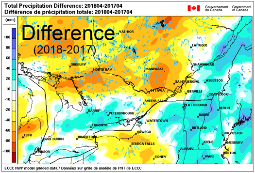
According to May 4 data from the International Joint Commission, a drier late winter/early spring across the southern Lake Ontario basin of New York state and the North Bay region-Ottawa River basin of Ontario, Canada, is credited with a significant drop in lake levels.
This factor, coupled with record high outflows from the lake over past months, has resulted in Lake Ontario levels being down 1-2 feet or more from the record highs of May 2017, according to local reports. And this comes despite water levels throughout the Great Lakes overall, including Lake Ontario, remaining above their long-term averages.
IJC reports water levels in the Lake Ontario-St. Lawrence River system is now encountering its typical spring rise. But due to several months of record high outflows from the lake into the St. Lawrence River at Massena and lower precipitation, Lake Ontario levels are now back within their normal range. They are expected to remain well below the historic high water event of last spring.
IJC notes the outflows from Lake Ontario into the St. Lawrence continue to be set according to Plan 2014. In past days, IJC began a reduction in outflows from the lake to ensure safe navigation and reduce flood risks in the St. Lawrence River, as levels on the river remain above average in response to the overall above-average levels of both Lake Ontario and the upper Great Lakes.
As is typical in spring, outflows from the Ottawa River into the St. Lawrence River have risen significantly in recent days in response to increased snowmelt and springtime precipitation. However, the Ottawa River Regulation and Planning Board said that, based on the remaining snowpack and weather forecasts, Ottawa River outflows are expected to remain within the normal range of fluctuations for this time of year.
Accordingly, the International Lake Ontario-St. Lawrence River Board has temporarily reduced outflows from Lake Ontario to balance the risks and impacts of upstream flooding and erosion (on both Lake Ontario and in the Thousand Islands), with the risks of similar impacts downstream in the St. Lawrence River from Montreal through to Three Rivers.
These flow adjustments are being done in accordance with Plan 2014 rules, which reflect operational practices developed over the decades to balance upstream and downstream flood risks.
Currently, the risk of significant flooding either upstream or downstream remains low.
The IJC Board said weather and hydrologic conditions play a more predominant role than water regulation in influencing water levels and, while impossible to predict, the probability of a repeat of last spring's exceptional rains and subsequent high water levels is low.
Water levels across the basin are expected to continue their seasonal rise over the next several weeks, and currently no indications exist that the extreme rainfalls that resulted in record Lake Ontario flooding last year will return.
The same holds true for the Ottawa River and the lower St. Lawrence River. IJC said current flow reductions from Lake Ontario are expected to be temporary. As the Ottawa River and levels downstream on the St. Lawrence begin to subside, outflows from Lake Ontario will be increased again.
Nonetheless, IJC said extreme conditions can occur at any time in any given year. During extreme rainfall events, water levels can rise quickly throughout the Lake Ontario-St. Lawrence River system and may be amplified by wind forces.
The IJC Board can do little to prevent this occurrence through outflow regulation, and so it urged property owners and community interests to remain diligent and have an emergency action plans in place to protect properties should these conditions occur.