


+70
°
F
+74°
+58°
Niagara Falls
Thursday, 16
See 7-Day Forecast
Featured News - Current News - Archived News - News Categories
Targeted work includes historic masonry wall, eastern shore bluff areas
By Terry Duffy
Editor-in-Chief
The U.S., Army Corps of Engineers, Buffalo District, has released its project findings for the Old Fort Niagara Streambank and Shoreline Erosion Protection Study. A 735-page report represents the federal government’s response to the Lake Ontario shoreline erosion problems that threaten historically significant structures at Old Fort Niagara. The focus centers on remediation measures intended to protect the fort’s historic masonry wall and adjoining shoreline bluff areas well into the future.
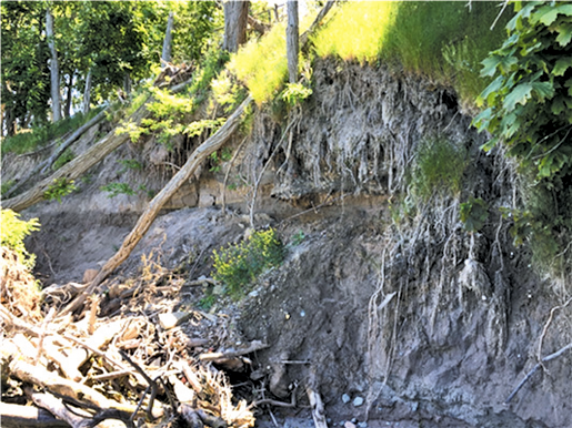
According to an Army Corps study undertaken over the past year, “Erosion directly to the east of the fort is currently outflanking the historical masonry wall and historic outercasement wall and presents a risk of failing within the next 0-2 years. …
“Both structures protect the historically significant buildings that are interior to the fort, including the ‘French Castle’ built in 1726 and the ‘North Redoubt’ built in 1771. The overall goal of this project is to protect the historically significant structure from Lake Ontario erosional forces.”
The Army Corps estimates the Old Fort Niagara improvement project at $5,982,000, including the latest feasibility study.
As an alternative, it projected a relocation cost of $16.2 million to cover the areas targeted for comparison purposes.
“Therefore the recommended plan is justified,” the Army Corps wrote.
It said this cost would be shared with the New York State Office of Parks, Recreation and Historic Preservation, its non-federal project sponsor. State Parks would be obliged to contribute 35% toward design and construction and pay for 100% of the cost of any operation and maintenance following construction.
As to the focus area of the planned work, the Army Corps said it encompasses reinforcing the historical masonry wall from the French Castle on the west adjacent to the Niagara River shore, to the North Redoubt area on the eastern end of the lakeshore. It also includes portions of the eastern bluff shore areas (approximately 400 linear feet) just north of the Fort Niagara State Park maintenance garages, which was listed as an “area of severe shoreline erosion,” and prone to impact from high water levels, waves, ice and shoreline erosion problems.
Other troubled shoreline areas at Fort Niagara State Park – those east of the park’s beach meadow area that are also experiencing severe erosion – were not included in the report.
“Higher water levels on Lake Ontario have contributed to significant erosion along the shoreline of Fort Niagara State Park and accelerated damage to the fort’s historic 19th century masonry wall that protects the original 18th century structures above it,” the Army Corps stated.
Focusing on both the masonry wall reinforcement and eastern bluff stabilization, the Army Corps offered three alternatives to address the problems. These include a “no action” scenario under alternative 1; a stone revetment and vegetative stabilization encompassing 450 feet with a total project cost of $6.603 million under alterative 2; and a similar plan of stone revetment, mechanically stabilized earth and vegetative stabilization totaling $5.281 million under alternative 3.
In its preferred choice of alternative 3, the Army Corps argued its remaining option – actual relocation of the affected areas – would total the aforementioned $16.2 million in cost, which was not deemed practical.
The Army Corps forecasted that, once complete, its shore remediation efforts would include reinforcements of the masonry wall areas and placement of boulders in the shore areas, among other measures, and would be designed to protect the affected areas for the next 50 years.
“It is recommended that ‘400 feet of shoreline protection consisting of a stone revetment, mechanically stabilized earth and vegetative stabilization’ be taken forward to the design and implementation phase. This alternative addresses the high rate of erosion and will protect Old Fort Niagara’s historical structures and contributing elements to the National Historic Landmark. The estimated project first cost for design and implementation of the recommended plan (is) $5,076,000, which is substantially less than the cost of relocating the structures at risk,” Army Corps District Cmdr. Eli S. Adams said.
The Army Corps is requesting comments from the public as it continues planning for the Old Fort Niagara Shoreline Protection project. A startup date for construction has not yet been determined. Written comments will be accepted until April 10 and can be emailed to [email protected].
The Draft Detailed Project Report and Environmental Assessment is available for public review via the U.S. Army Corps of Engineers – Buffalo District website at https://www.lrb.usace.army.mil/Missions/Civil-Works/Public-Review-Documents.
Shoreline Update
The Army Corps’ latest effort comes at a time when Lake Ontario water levels have actually declined following years of record-high water levels, lake flooding and shoreline erosion.
The lake, as of late February-early March, is 4 inches below its long-term averages at 244.24 feet, according to the data from the International Joint Commission.
Such was not the case in recent years -- particularly from 2017 through 2019, where heavy precipitation events and melting snowfall in the Midwest and Great Lakes region resulted in record-high water levels, flooding and extensive (and costly) shore damage throughout the Lake Ontario basin shore areas in the U.S. and Canada.
Those conditions led to significant changes in how the IJC controls Lake Ontario water levels under ILC Plan 2014. Throughout 2020 and continuing to this day, IJC has continued its practice of record outflows through dam facilities at Massena, New York, and into the upper St. Lawrence River.
According to the March 1 IJC report, “The risk of flooding on Lake Ontario and the upper St. Lawrence River has declined from moderate in December to low (presently). In December, the risk analysis indicated a 28% chance of water levels exceeding the threshold at which damages occur in many shoreline communities. The risk is now down to 8%. …
“This risk reduction is largely the result of dry conditions throughout the Great Lakes basin in January and February. Lake Ontario water levels declined 8 cm (3-5/32 inches) in January and 7cm (2-3/4 inches) in February.”
IJC said Lake Ontario stands at 4.3 inches below its long-term average and close to 2 feet lower than it was a year ago at this time. The favorable trend is seen in the other Great Lakes levels, as well, with IJC noting Lake Erie has also declined by a foot from last year.
“Given these factors, the board has decided to cease deviating from Plan 2014 on 1 March and revert to the high outflows prescribed by Plan 2014,” IJC said. It plans to continue this practice through the Ontario’s seasonal crest into the spring of 2021.
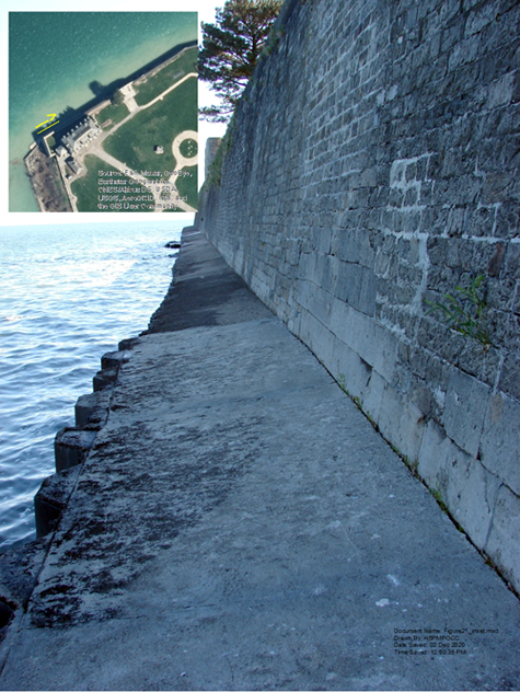
A 2013 photo of the existing masonry wall on the lakeshore fronting the French Castle at Old Fort Niagara. Inset is an aerial view of the castle and the planned work area. (Army Corps photo)


1859 Whitehaven Road, Grand Island, NY 14072
Phone: 716-773-7676
Fax: 716-773-7190
